
Page 162 - New Trends in Green Construction
P. 162
Advanced Construction Materials and Technologies
matched the master station used by the MAC. The dual-frequency GNSS receiver used in this work was a Leica GG AX (Hexagon AB, Stockholm, Sweden), mounted on a pole and equipped with an internet-connected mobile phone to receive differential corrections from the selected station through the NTRIP (Networked Transport of RTCM via Internet Protocol) (Lenz, 2004). The Andalusian Positioning Network (RAP) of the Andalusian regional government was used as the active geodetic network.
3. Results and Conclusions.
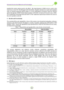
The reproducibility and repeatability values of the system were determined using three reference antennas in the RAP network (Pozoblanco, Cazalla, Córdoba), applying the UNE 82009-2:1999 standard. Table 1 shows the repeatability and reproducibility values for the different levels tested, in both position and height.
Table 1 - Repeatability and reproducibility values for the six levels tested.
Repeatability Position Height
Reproducibility
Point
Position
Height
1 0.005 0.012
2 0.006 0.017
3 0.005 0.016
4 0.006 0.009
5 0.006 0.010
6 0.006 0.013
0.014 0.031 0.007 0,038 0.007 0,036 0.014 0.045 0.011 0.023 0.013 0.029
0.011 0.034
Average
0.006 0.013
The average planimetry and altimetry results obtained,
reproducibility, allow us to state that the real-time services offered by the RAP network are suitable for use in construction works for engineering projects. In addition, since the base receiver is one of the antennas in the RAP network, this saves both time and money. Time-wise, this process eliminates the set-up period associated with the GNSS antenna that serves as the master. Moreover, since it is only necessary to acquire a single GNSS receiver, the financial costs associated with the work are further reduced.
4. References
Hofmann-Wellenhof B. et al. (2001). GPS Theory and Practice Fifth Revised Edition, Springer-Verlag Wien New York, ISBN 3-211-835342. Remondi, BW (1985), Performing Centimeter-Level Surveys in Seconds with GPS Carrier Phase: Initial Results. Navigation, 32: 386-400. doi:
10.1002 / j.2161-4296.1985.tb00918.x
Fotopoulos, G. and Cannon, ME (2001) An Overview of Multi-Reference Station Methods for Cm-Level Positioning, GPS Solutions , Vol. 4,
No. 3, 1-10, 2001
Curls C; Han S, 'Reference station network based rtk system - concepts & progress', in 4TH International Symposium ON GPS / GNSS , Wuhan,
China, 6 - 8 November 2002.
Aponte, J., Meng, X., Dodson, AH, Moore, T., Hill, C., Burbidge , M.Quality assessment for a network RTK GPS service in the UK (2009) J.
Appl. Geodesy, 3, pp25 34
Euler H.-J., Keenan CR, Zebhauser CB, Wübbena G., "Study of Simplified Approach in Utilizing Information from Permanent Reference Station
Arrays", presented at ION GPS 2001.
Janssen V. "A comparison of the VRS and MAC principles for network RTK" Proceedings of the IGNSS Symposium. Australia Dec 200
N. Brown, R. Keenan, B. Richter, L.Troyer, Advances in ambiguity resolution for RTK applications using the new RTCM V3.0 Master-Auxiliary
messages Leica Geosystems AG, Switzerland Published in proceedings of ION GNSS September 13-16, 2005, Long Beach, CA
Lenz, E. Networked transport of RTCM via internet protocol (NTRIP) - application and benefit in modern surveying systems, FIG Working Week,
Athens, Greece, May 22-27, 2004. Int. Paper TS3.2
Berrocoso, M., Páez, R., Jigena, B., Caturla, C. The RAP Net: A Geodetic Positioning Network for Andalusia (South Spain). Riga, Latvia, June
14-17 2006, EUREF Publication No. 16, Mitteilungen des Bundesamtes für Kartographie und Geodäsie, Band 40, pp. 364-368. ICA-
UCA.2007
Spanish Standard UNE 8002009-2, (1999). Accuracy (trueness and precision) of measurement methods and results, published by AENOR Legal
Deposit: M 235781.199
162
considering repeatability and
